The December 2013 Floods - a north Norfolk perspective
by Andy Stoddart
The spectre of 31st January 1953 has long haunted Britain’s east coast, particularly that of East Anglia. On that infamous night over 300 lives were lost and 24,000 properties damaged. Subsequent ‘surges’ have reminded us that such catastrophic events could one day be repeated. Those of 11th January 1978, 19th-20th February 1996 and 9th November 2007 were not as severe as that of 1953 but were still serious, flooding roads and property and reshaping the coastal landscape. Over sixty years have elapsed, however, since anything on the scale of 1953.
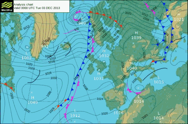
The surge of 5th December 2013 came almost out of nowhere. A developing wave depression off Newfoundland on the night of 3rd December looked normal but it accelerated rapidly across the western Atlantic on the morning of 4th and was already in mid-ocean by midday. By midnight on 4th it lay between Iceland and northern Scotland and its central pressure had fallen to 987 millibars. What had started as an apparently ordinary feature was now moving very rapidly and deepening fast. By midday on 5th the low centre, now registering only 976 millibars, was over southern Norway and was pulling in increasingly violent winds around its trailing edge, the pressure gradient squeezed and steepened by a high pressure over the Azores. The strongest winds lay at first across Scotland and northern England, where they caused widespread disruption, but soon they were heading south and their direction shifting from the west into the northwest. The narrow cold front marking this shift in wind direction moved south across the country during 5th, crossing East Anglia during the early afternoon and turning the winds in north Norfolk onshore.
That morning the forecasters correctly predicted a surge in the North Sea, the depth of the low pressure raising the sea around two meters above normal levels. Combined with the violent winds around the rear of the depression and a high new moon tide, a disaster in the low-lying areas around the southern North Sea was now looming. Though high water was not due until mid-evening, water levels were already exceptionally high by late afternoon and Wells Quay was quickly over-topped. The full onslaught was, however, shrouded in darkness and as the surge moved around the coast from Lincolnshire and the Wash to Norfolk, Suffolk and finally to Essex and Kent, its greatest dramas were witnessed only by those right on the front line.
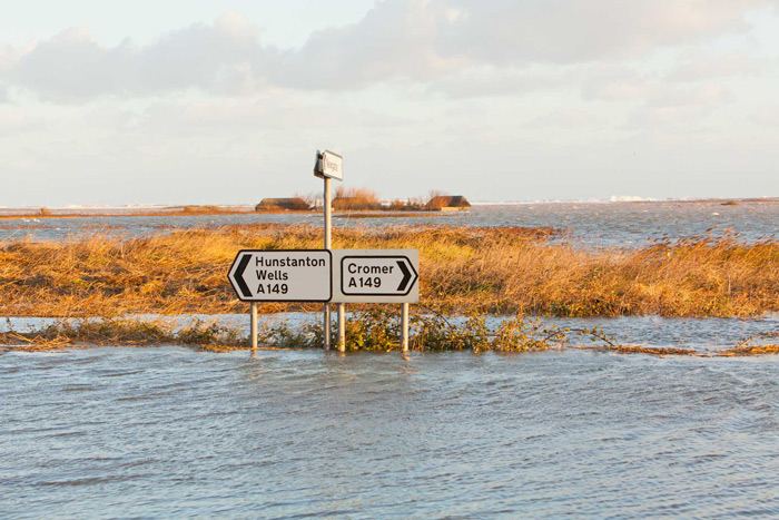
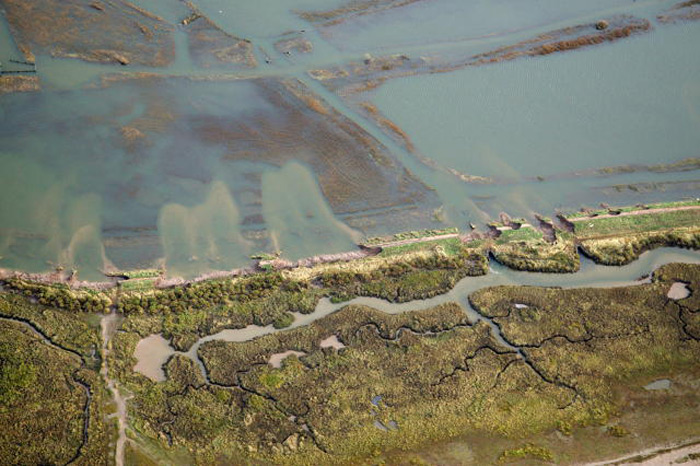
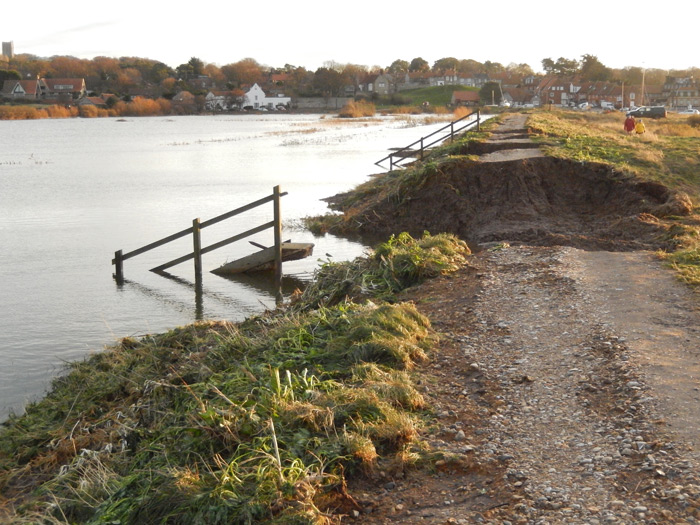
For most, the full consequences could not be appreciated until next day. At first light the scene in north Norfolk was truly dramatic. Gone was the familiar mosaic of reedbed and grazing marsh against a backdrop of dune and shingle ridge. Instead, an unforgettable scene met the eye - the old landscape, including parts of the A149 coast road, wholly submerged beneath a newly-racing tide. At Cley the whole reserve lay under many feet of water, with only the tops of the Daukes cluster of hides visible. North Hide was nowhere to be seen, the northern boundary of the reserve now marked by an, in places, barely visible shingle bank and, behind, by great tumbling waves. At Salthouse, just west of the Little Eye and the now-vanished beach car park, the sea had sliced through the shingle bank down to below the normal high water mark, enabling the tide to flow freely through the gap. Elsewhere, whole sections of the ridge had been washed inland to form great shingle ‘fans’, burying all in their path. Water overran and breached the seawalls too. The West Bank at Cley was ruptured in three places but the Blakeney Bank fared much worse, with over a dozen great gashes along its length and boats marooned on top.
On the inland side of the coast road, the water reached some distance into low-lying fields, high up house and garden walls and into a number of properties. Wells, Blakeney, Cley and Saltouse all had flooded houses. Just as bad for property-owners were the great accumulations of reed debris marking the high water line. These completely blocked the coast road, clogged drives and gardens and remained draped high in bushes and hedges. Most choked by this reed debris was Kelling Quags. Here the wind had driven tons of this material, along with silage bales and a variety of other flotsam, from some miles to the west. Here could be found small boats from Blakeney, parts of Cley’s North Hide and the information sign from the East Bank car park.
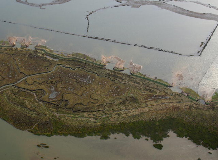
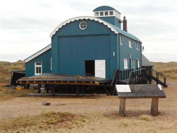
At Blakeney Point the shingle had, as usual, rolled a little inland, burying some stretches of Suaeda, and of course the beach top vegetation was gone but, surprisingly, the far spits most exposed to the wind and waves looked largely as they had done before. The Lifeboat House, fared less well, however. Despite being raised on stilts, its ground floor was under a foot of water and the Lupins was a swimming pool for seals.
Elsewhere along the coast it was a similar story. Snettisham was badly knocked about, with hides severely damaged and uprooted, Holme suffered damage to its outer fringe and the stretch of dunes from Titchwell towards Brancaster almost completely disappeared. The Titchwell reserve lost its boardwalk and some water overtopped the public footpath but the damage here could have been worse. The freshmarshes at Burnham Norton and Burnham Deepdale were badly flooded but the Wells Beach Road bank held and the caravan site survived. To the east, the Sheringham and Cromer seafronts were damaged, with water overtopping Cromer pier, but it was the total loss of several coastal properties around the coast at Hemsby which captured most of the press interest and which provided the most lasting and widely-published photographic record of the great flood.
Back at Cley, the immediate effects on birds and other wildlife were striking. Mute Swans and even a Grey Seal could now swim happily along the coast road whilst the whole stretch between Blakeney and Kelling was for a while suitable only for wildfowl. As the tide receded, great hordes of Black-headed and Common Gulls descended on the sudden great earthworm feast, a strange echo of their more normal tractor-following. Other birds fared less well. For a while, the entire reedbed habitat was either submerged, flattened or washed away and forlorn groups of Bearded Tits could be seen flying restlessly about and perching incongruously in bramble bushes. Quite where the exotic wildfowl from the Blakeney duck pond collection have ended up remains to be seen.
The dire predictions about the Blakeney Point Grey Seal colony fortunately proved groundless, however. With record-breaking numbers of pups (1200+) just before the storm, there were great concerns about their survival. Amazingly, however, the vast majority survived, with numbers there continuing to grow.
The more long-term effects of the inundation remain to be seen. Water has run off Cley and Salthouse fresh marshes surprisingly rapidly, thanks to the recent spillway created in the East Bank and the improved sluices in the West Bank. At Blakeney, however, the fresh marshes remain at the time of writing under a considerable depth of water and the long-term effects here may be more serious. History tells us, though, that these areas can and do recover, at least until next time.
Final reports suggest that the surge of 5th December was at least equal to and probably greater than that of 1953. This time, fortunately, the consequences were much less serious in human terms. No lives were lost and much less property was flooded, thanks mainly to improved hard defences, to much better forecasting and communication and to the work of the statutory and voluntary bodies.
Perhaps the main lesson, as on such occasions before, is that it is the human structures which suffer most, the coast’s natural features moving around and accommodating themselves much more readily to the elements. The most damaged portions of the shingle bank were generally those previously artificially banked up, whilst Blakeney Point, despite its apparent fragility and being almost wholly submerged, emerged essentially unscathed from the waves.
This should not be a surprise, however. The landscape along much of this stretch of coast is a human artefact, borrowed from the sea ever since the construction of the retaining banks in the 1650s. It is perhaps only right that, from time to time, the sea comes back to reclaim its ancient domain.
Andy Stoddart